Stage IV Precipitation
Overview
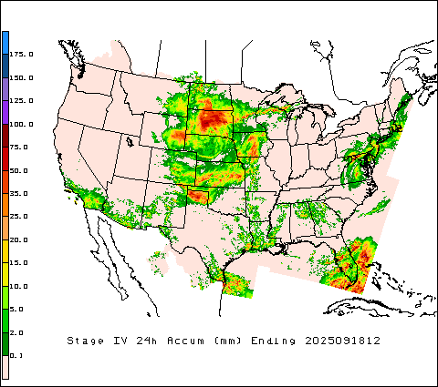
The NCEP “Stage IV” precipitation product is a national, multi-sensor quantitative precipitation estimate (QPE) created by mosaicking the 12 NWS River Forecast Centers’ hourly/6-hourly Stage III analyses—each of which blends WSR-88D radar with rain-gauge observations and RFC forecaster quality control—onto a common ~4 km HRAP grid for CONUS (with extensions for Alaska and Puerto Rico). It is delivered as hourly, 6-hourly, and 24-hour accumulations, with the key distinction that Stage IV benefits from manual QC inherited from the RFC inputs, in contrast to automated-only Stage II.
The Stage IV data is a combination of observations and radar calculated reflectivity. Therefore the data combines the advantage of ground-truth provided by gauges with the spatially complete and high resolution radar data. Operationally, Stage IV is widely used for hydrologic verification, flood event forensics, and as precipitation forcing for models and water-resources studies. Data are distributed in GRIB (now GRIB2, after a 2020 format change) and the hourly product is available in near real-time via NOMADS.
Additional reading
Put your bibliography here